

")
")
")
")
")
")

Description
I am selling a Sensors & Software LMX100 GPR System. This ground penetrating radar set-up is in good condition and ready to work.
LMX100™ for Buried Utility Locator | Sensors & Software Inc.
The detection and mapping of buried utilities is a major application area for GPR. Using radio waves, GPR offers a rapid way to accurately locate metallic and non-metallic utilities as well as other ancillary targets such as underground storage tanks, splice pits and buried manholes. GPR complements traditional electromagnetic (EM) methods of pipe and cable locating by providing a complete underground picture. Understanding where and when a particular approach is most cost-effective comes from experience, business practice, and local construction techniques.The following example illustrates how the LMX100™ system is for locating buried utilities.
Methodology for Using GPR to Locate Buried Utilities
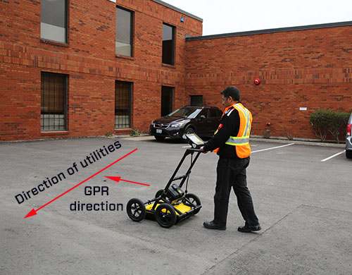
Locate and mark is the most common way of using GPR to track utilities. The GPR sensor is moved along sweeps perpendicular to the anticipated utility direction (Figure 1) in a zig-zag direction.

The GPR sensor is moved along sweeps perpendicular to the anticipated utility direction in a zig-zag direction.
When the GPR unit crosses the utility, the image shows a hyperbolic shape (inverted V) such as depicted in Figure 2. The apex or top of the hyperbola is the position of the utility. The distance to the top of the hyperbola is an estimate of depth. By moving the GPR back and forth and marking the ground where the top of the hyperbola is observed, the alignment of the subsurface utility can be traced out.


Instrumentation
The LMX100™ system (shown in Figure 3) provides an excellent example of a GPR system optimized for utility locating. The collapsible cart is constructed of tough non-metallic fiberglass components and features large diameter wheels and a highly-visible data display. The system is designed for easy shipping and storage. Set-up time from arrival on site to the start of data collection takes less than two minutes.
The high-resolution Display Unit is a rugged, weatherproof field computer used for recording and displaying data. Visible in all lighting conditions – including bright sunlight – the Display Unit is designed for rough field conditions and works over a wide temperature range. The resistive touchscreen allows for quick operation, even if the input is conducted while wearing gloves. The Display Unit’s intelligent, user-friendly firmware makes data collection simple and straightforward, while the back-up arrow provides pinpoint accuracy of the exact location of a target.
The integrated Display Unit, battery and wheel odometer makes it easy to do controlled surveys, offering greater efficiencies. A full day of surveying requires just one rechargeable gel cell battery. GPS positioning is designed into the LMX100 system. Save time and enhance productivity by emailing a mini-report straight from the field using the built-in WiFi capability.


Reviews
There are no reviews yet.